The English encyclopedia Allmultimedia.org will be launched in two phases.
The final launch of the Allmultimedia.org will take place on February 24, 2026
(shortly after the 2026 Winter Olympics).
Dovolená : 23. prosinec 2025 — 29. prosinec 2025
Holidays : December 23, 2025 — December 29, 2025
The final launch of the Allmultimedia.org will take place on February 24, 2026
(shortly after the 2026 Winter Olympics).
Dovolená : 23. prosinec 2025 — 29. prosinec 2025
Holidays : December 23, 2025 — December 29, 2025
Soubor:Guadeloupe map.png
Z Multimediaexpo.cz
Větší rozlišení není k dispozici.
Guadeloupe_map.png (rozměr: 315 × 337 pixelů, velikost souboru: 10 kB, MIME typ: image/png)
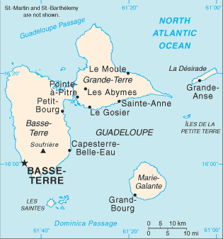
Mapa + Description: Map of the French overseas département of Guadeloupe showing major cities.
- Date: 2006
- Source: CIA, The World Factbook: https://www.cia.gov/library/publications/the-world-factbook/geos/gp.html
- Author: CIA
+ pochází z Wikimedia Commons, kde má status – This image is a work of a Central Intelligence Agency employee, taken or made as part of that person's official duties. As a Work of the United States Government, this image or media is in the public domain in the United States.
Historie souboru
Kliknutím na datum a čas se zobrazí tehdejší verze souboru.
| Datum a čas | Náhled | Rozměry | Uživatel | Komentář | |
|---|---|---|---|---|---|
| současná | 10. 4. 2014, 11:02 | | 315×337 (10 kB) | Sysop (diskuse | příspěvky) | (MW1.15-Fotografie) |
- Editovat tento soubor v externím programu (Více informací najdete v nápovědě pro nastavení.)
Odkazy na soubor
Na soubor odkazují tyto 3 stránky:


